
Exporting individual laps from AIM RaceStudio2 to GoogleEarth
 09-16-2015, 03:35 PM
#16
Rennlist
Basic Site Sponsor
Basic Site Sponsor
Join Date: Jun 2008
Location: Durham, NC and Virginia International Raceway
Posts: 18,724
Received 2,886 Likes
on
1,694 Posts
Yep. Love 20 Hz MoTeC and VVBOX exports. Hopefully, AiM Sports soon...
__________________
-Peter Krause
www.peterkrause.net
www.gofasternow.com
"Combining the Art and Science of Driving Fast!"
Specializing in Professional, Private Driver Performance Evaluation and Optimization
Consultation Available Remotely and at VIRginia International Raceway
-Peter Krause
www.peterkrause.net
www.gofasternow.com
"Combining the Art and Science of Driving Fast!"
Specializing in Professional, Private Driver Performance Evaluation and Optimization
Consultation Available Remotely and at VIRginia International Raceway
 09-17-2015, 09:29 AM
#18
Rennlist
Basic Site Sponsor
Basic Site Sponsor
Join Date: Jun 2008
Location: Durham, NC and Virginia International Raceway
Posts: 18,724
Received 2,886 Likes
on
1,694 Posts
09-17-2015, 10:30 AM
#19
Advanced
Join Date: May 2008
Posts: 84
Likes: 0
Received 0 Likes
on
0 Posts
Yes it appears what I uploaded is only the red lap. Sorry. I think it showed 2 for me because it was linking to the other kml lap on my desktop and apparently you can't save both laps in to a new KML using ge but you can open multiple colored laps and compare them in ge.
In my video there is a text field in gpsprune that I stupidly said means nothing…this is the field where we should note lap3 of test 1 or whatever your naming convention is…then this becomes a layer in ge and you can turn on many layers in different colors. I just looked at 3 that came from AIM. So you can have many laps from many sessions.
Original process: I exported 1 test from AIM. Using gpsprune I exported 2 different laps and made them different colors. So I now have 2 KML files. Then I opened the first kml and then went to file open and opened a 2nd kml and the 2nd shows within the first. So you add them in and I think they are temporary. When you quit ge they are not compiled in to one. So each time you open and add them to view.
Here is another link with 2 individual laps that you can open one then the other and it should work. https://goo.gl/E9j7SB
Let me know if it again does not work because it works excellent here. We just have to manually make them to compare them in ge. AIM will solve this I think.
09-18-2015, 09:55 PM
#20
Three Wheelin'
Tentenths
Thanks for sharing. It did work for me. I'll give it a try on some of my data. Let's hope AIM will get this feature added, but they are working on some cool stuff now, so we'll see.
Thanks for sharing. It did work for me. I'll give it a try on some of my data. Let's hope AIM will get this feature added, but they are working on some cool stuff now, so we'll see.
09-23-2015, 09:48 AM
#22
The Penguin King
Rennlist Member
Rennlist Member
Ok, I was able to display laps in Google Earth, which is VERY cool. However, when I compare from two different sessions, GPS drift makes it a bit difficult. I know that in Traqview, you can adjust sessions so that they overlay to correct for this. Is there any way to do this in RS2, or in Google Earth?
09-24-2015, 11:30 AM
#24
Three Wheelin'
If you are trying to line up laps in RS 2 that were done at different times, you could try going to Lap Manager tab (at the bottom) and click on GPS Lap Insert (upper right) and use the current Lat and Long in GPS manager. This will line up start finish, but might not affect "drift"
10-29-2015, 07:46 PM
#25
Ok, I was able to display laps in Google Earth, which is VERY cool. However, when I compare from two different sessions, GPS drift makes it a bit difficult. I know that in Traqview, you can adjust sessions so that they overlay to correct for this. Is there any way to do this in RS2, or in Google Earth?
On viewing the 4 laps as KMZs superimposed on Google Earth it was obvious to me too that there was up to about 10 feet of GPS drift between some of them. To correct this, I needed a known reference point where I'd know the car had to be in the same place each lap, even with different drivers. Couldn't quite find such a spot on their live laps, but the pit entry chicane was ideal as it is very tight and narrow with big kinks, and the slow speed of the car made the most of the GPS sample rate. So I worked out the GPS offset (well offsets actually - for both latitude and longitude) needed to put the car through that chicane without taking out a wall then imported the CSVs into Excel and applied that same correction to the lap of interest in that same session, renamed it to KMZ (and maybe had to add a bit of a header but its a couple of years ago now so don't quite remember).
On loading those back into Google Earth it all looked right after that correction, allowing proper comparison of lines. Can't post the map to illustrate sorry as it's back at home. The key is just to pick a tight and bendy spot where you know the car will be, though you could also do it as a two step process by looking for one spot on track where it is constrained on the Longitude axis and another where it is constrained on the Latititude axis to work out each offset.
Am still keen to hear about any tools that would make doing the above a bit faster and easier though. Maybe Google Earth itself now has a simple tool to drag and drop the lines around to align them to such a reference point or points?
10-30-2015, 06:58 PM
#26
Three Wheelin'
AIM next gen GPS will be more accurate than today so that will help. We (dealers and users0 all are asking for the ability to export single laps, preferably laps overlaid in comparison. Give it time, this is complex stuff.
01-29-2016, 01:11 AM
#27
...On loading those back into Google Earth it all looked right after that correction, allowing proper comparison of lines. Can't post the map to illustrate sorry as it's back at home.
...
Am still keen to hear about any tools that would make doing the above a bit faster and easier though. Maybe Google Earth itself now has a simple tool to drag and drop the lines around to align them to such a reference point or points?
...
Am still keen to hear about any tools that would make doing the above a bit faster and easier though. Maybe Google Earth itself now has a simple tool to drag and drop the lines around to align them to such a reference point or points?
I was quicker through here by 0.6s but have since changed my line again, now running the second inside kerb.
He was quicker be the same margin through another corner, shown in the standard AIM view (pink, orange being faster, running right to left) below. Having a map under the lines helps a lot with putting changes into practice.
02-21-2016, 12:02 PM
#28
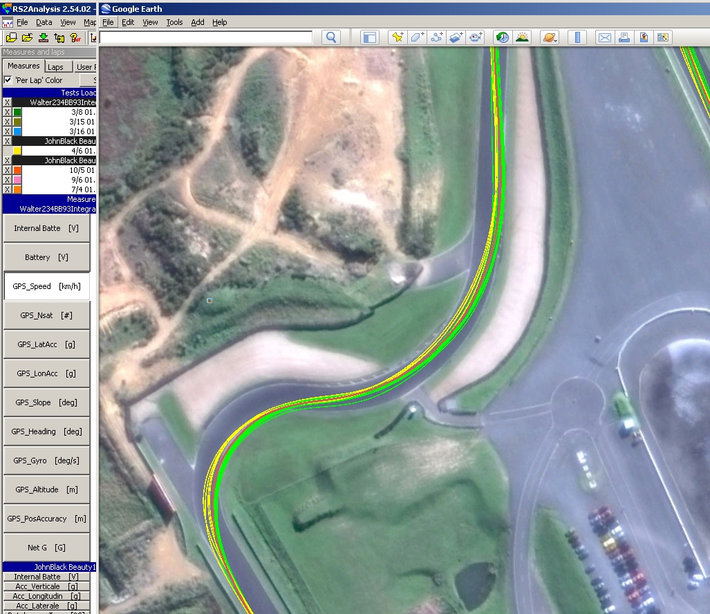
AiM Race Studio 2 has just been updated and one of the updates allow track sessions to be exported in the Google Earth .kml format with individual lap placemarks. With these placemarks included, once in Google Earth you can easily change the properties (line color, width, transparency, etc.) for individual laps.
In RS2 with an open test, go to 'File'=>'Data Export to Excel' menu item and select the 'KML' format and finally select the laps (some or all) that you want exported.
In RS2 with an open test, go to 'File'=>'Data Export to Excel' menu item and select the 'KML' format and finally select the laps (some or all) that you want exported.